|
Plenary
Lecture
Current Research Trends and Applications in Urban Remote
Sensing

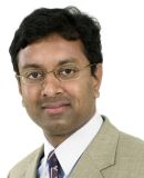
Dr. Sunil Bhaskaran
Bronx Community College/CUNY
Dept of Chemistry & Chemical Technology
2155 University Ave, Bronx, NY 10453
USA
E-mail:
sungis@hotmail.com
Abstract: The talk focuses on current trends in
urban remote sensing, and discusses the importance of
spectral and object-oriented classification methods for
mapping urban features from multispectral and
hyperspectral remotely sensed data. By giving examples
from 2 projects undertaken in Sydney, Australia and New
York, USA, importance aspects of remote sensing
applications for urban environments are presented.
Decomposing the image pixel is the main goal in urban
remote sensing. However, extracting features from urban
environment is challenging due to the heterogeneity of
urban features and limited spectral separability of
certain urban features such as building roofs, roads,
open spaces. The importance of combining spectral and
object-oriented classification is highlighted in this
presentation. An overview of object-oriented
classification is also presented.
Brief Biography of the Speaker:
Dr. Bhaskaran has a PhD (2003) in remote sensing and
Geographic Information Systems (GIS) from the School of
Geomatic Engineering, University of New South Wales,
Sydney. Dr. Bhaskaran's research interests are in
spatial analysis, image analysis, modeling, data
integration and decision support systems. Dr. Bhaskaran
has over 10 years of experience in teaching GIS and
remote sensing at the post graduate, graduate and
undergraduate levels in Australia. Dr. Bhaskaran has
developed new course materials on 'Web Based GIS',
tutorials in GIS and remote sensing and delivered
several workshops to students and staff from the
Industry including the Food and Agricultural
Organisation (FAO). Dr. Bhaskaran has also designed
projects in geospatial technology for schools in
Australia and has been the examiner of online courses.
Dr. Bhaskaran has over 12 years of research experience
in developing GIS and remote sensing applications for a
wide range of applications. Since 1999, Dr. Bhaskaran
has collaborated with various government and commercial
agencies in geospatial projects. He has managed several
international geospatial projects and mentored and
supervised many researchers and honors students. Dr.
Bhaskaran has been awarded over $500,000.00 of grant
funding and has also received the Australian Research
Council Award for Linkage and Infrastructure (ARC-LIEF).
By analyzing and integrating hyperspectral remote
sensing and GIS data, Dr. Bhaskaran developed a unique
model to map vulnerability from Hail Storms in Sydney.
This project and publication in the 'International
Journal of Remote Sensing' is widely cited by peers all
over the world. Dr. Bhaskaran has won several awards in
research throughout his career. Dr. Bhaskaran has
published over 40 research papers in peer reviewed
journals and proceedings of conferences. In 2001 his
paper 'Sub-Pixel analysis of the Urban Environment' was
nominated as one of the best papers at the prestigious
IEEE/IGARSS symposium. Dr. Bhaskaran is an invited
member of peer-review panel on several international
journals. He was an invited joint editor for a special
issue on 'Hyperspectral Remote Sensing' that featured in
the International Journal of Geoinformatics. In 2005,
Dr. Bhaskaran was invited as a 'Visiting Scientist' to
the prestigious 'ITC' institute in Netherlands. Dr.
Bhaskaran is currently co-authoring a book on
hyperspectral applications to be published by Springer-Verlag,
Holland. Dr. Bhaskaran has served on various spatial
sciences committees both at the regional and national
levels notably the Spatial Sciences Institute (SSI) and
the Queensland fire and biodiversity consortium. He has
served as the member of the 13th Australasian
Photogrammetry and Remote Sensing Conference (ARSPC) and
was the Deputy Chair of the Program Committee. Dr.
Bhaskaran has received certificates and commendations
for his outstanding contribution to spatial sciences.
Dr. Bhaskaran is currently collaborating with GeoEye for
conducting research on mapping urban features from high
spatial resolution satellite data over New York City. He
is developing algorithms using both spectral and spatial
attributes for automated mapping of urban features.
Currently, Dr. Bhaskaran teaches and conducts research
in Geographic Information System (GIS) and remote
sensing at the department of Environmental, Geographic
and Geological Sciences, Lehman College, City University
of New York. Dr. Bhaskaran is an Australian citizen but
resides now in US as a permanent resident.
|
