|
||||||||||||||
|
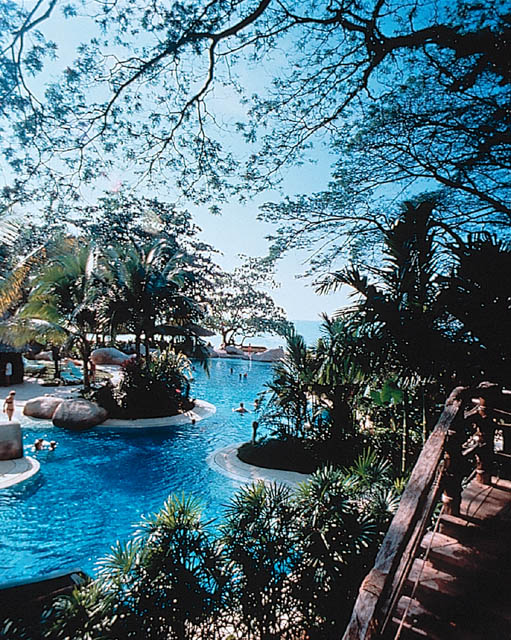
LOCATION: Penang. Malaysia, March 23-25, 2010http://www.wseas.org/conferences/2010/penang/aee/index.html Bayview Beach Resort, Batu Ferringhi Beach, 11100 Batu Ferringhi, Penang, Malaysia. Tel: 04-8812123 / Fax: 04-8812955, Mobile: 012-4108636, www.bayviewhotels.com
PENANG (from Wikipedia)The island was referred to as 檳榔嶼 (Bīnl�ng Y�) in the navigational drawings used by Admiral Zheng He of Ming-dynasty China in his expeditions to the South Seas in the 15th century. Early Malays called it Pulau Ka-Satu or "First Island". The name "Penang" comes from the modern Malay name Pulau Pinang, which means island of the areca nut tree (Areca catechu, family Palmae). The name Penang can refer either to the island of Penang or the state of Penang. The capital of Penang state is Georgetown. More specifically, Georgetown is also called Tanjung in Malay. Penang Island is simply Pulau Pinang(/'pulaʊ 'pinaŋ/) and Penang state is Negeri Pulau Pinang in Malay. Penang is severally known as "The Pearl of the Orient" and "Pulau Pinang Pulau Mutiara" (Penang Island of Pearls).
HistoryPenang, originally part of the Malay Sultanate of Kedah, was given to the British East India Company in 1786 by the Sultan of Kedah, in exchange for military protection from Siamese andBurmese armies who were threatening Kedah. On 11 August 1786, Captain Francis Light, who was credited as the founder of Penang, landed in Penang and renamed it Prince of Wales Island in honour of heir to the British throne. Many early settlers succumbed to malaria, earning Penang the "the White Man's Grave" epithet. [2] Unbeknownst to the Sultan, Light had acted without the approval of the East India Company when he promised military protection. When the Company failed to aid Kedah when it was attacked by Siam, the Sultan tried to retake the island in 1790. The attempt was unsuccessful, and the Sultan was forced to cede the island to the Company for an honorarium of 6,000Spanish dollars per annum. This was later increased to 10,000 dollars, with Province Wellesley on the mainland of the Malay Peninsula being added to Penang in 1800. An annual honorarium of 10,000 ringgits continues to this day be paid by the Malaysian Federal Government to the state of Kedah. In 1826, Penang, along with Malacca and Singapore, became part of the Straits Settlements under the British administration in India, moving to direct British colonial rule in 1867. In 1946 it became part of the Malayan Union, before becoming in 1948 a state of the Federation of Malaya, which gained independence in 1957 and became Malaysia in 1963. The island was a free port until 1969. Despite the loss of the island's free-port status, from the 1970s to the late 1990s the state built up one of the largest electronics manufacturing bases in Asia, in the Free Trade Zone around the airport in the south of the island. On 7 July 2008, Georgetown, the historic capital of Penang was formally inscribed as a UNESCO World Heritage Site alongside with Malacca. It is officially recognized as having a unique architectural and cultural townscape without parallel anywhere in East and Southeast Asia.[3]
GeographyThe state is geographically divided into two sections:
The body of water between Penang Island and Province Wellesley is the North Channel to the north of Georgetown and the South Channel to the south of Georgetown. Penang Island is irregularly shaped, with a granitic, hilly and mostly forested interior, the highest point being Western Hill (part ofPenang Hill) at 830 metres above sea level. The coastal plains are narrow, the most extensive of which is in the northeast which forms a triangularpromontory where Georgetown, the state capital, is situated. The topography of Province Wellesley is mostly flat. Butterworth, the main town in Province Wellesley, lies along the Perai River estuary and faces Georgetown at a distance of 3 km (2 miles) across the channel to the east.
TownsPenang Island Air Itam - Balik Pulau - Bandar Baru Air Itam - Batu Ferringhi - Batu Maung - Batu Lanchang - Bayan Baru - Bayan Lepas - Gelugor - Georgetown -Green Lane - Gurney Drive - Tanjung Tokong - Jelutong - Paya Terubong - Pulau Tikus - Pulau Betong - Sungai Ara - Sungai Dua - Sungai Nibong - Tanjung Bungah - Tanjung Tokong -Teluk Bahang Province Wellesley Alma - Bagan Ajam - Bagan Luar - Batu Kawan - Bukit Mertajam - Bukit Minyak - Butterworth - Jawi - Juru - Kepala Batas - Mak Mandin - Nibong Tebal - Pantai Aceh - Permatang Pauh -Perai - Raja Uda - Seberang Jaya - Simpang Ampat - Sungai Bakap - Bukit Tambun - Permatang Tinggi Greater Metropolitan Area of PenangThe National Physical Plan of Malaysia envisages a Conurbation of Georgetown encompassing George Town and surrounding areas. The Conurbation of Georgetown, together with theConurbation of Johor Bahru are designated as Regional Growth Conurbations while the Conurbation of Kuala Lumpur is the National Growth Conurbation. The greater metropolitan area of Penang consists of highly urbanized Penang Island, Seberang Prai, Sungai Petani, Kulim and the surrounding areas. In terms of population, it is the second largest metropolitan area in Malaysia after the Conurbation of Kuala Lumpur (Klang Valley). According to National Census 2000, the population of this urban area in is about 1.6 million. As for the Conurbation of Kuala Lumpur, the population in 2000 is about 4.9 million while the population of Johor Bahru is 1.5 million. Currently, the population of this urban area is approximately 2 million. [4] This urban area is referred to as the Northern Corridor Economic Region (NCER) under a repackaging of the Ninth Malaysian Plan (a five-year national development plan) which was announced earlier. The NCER is one of three development regions identified in Peninsular Malaysia, other development regions being the South Johor Economic Region (SJER) or Iskandar Development Region (IDR) and the East Coast Development Region. The NCER encompases Penang (Penang Island and Seberang Prai), Kedah (Alor Star, Sungai Petani and Kulim),Perlis (Kangar) and Northern Perak. Unfortunately, the Barisan Nasional-controlled federal government has decided to defer the two much-delayed major development projects of Penang Outer Ring Road and Penang Monorail following their dismal performance at the 12th General Election of 3 March 2008 which saw three northern states of Penang, Kedah and Perak falling to the opposition. Nevertheless, the federal authority cited economic situations for the deferment. Penang Global City Centre (PGCC), another high-impact projects of NCER featuring state-of-art design of futuristic landmark twin towers, has also run aground following its rejection by thePenang Municipal Council in September 2008. It remains to be seen if the PGCC will be resurrected.
Outlying isletsThere are a number of small islets off the coast of Penang, the biggest of which, Pulau Jerejak, is located in the narrow channel between Penang Island and the mainland. It was previously a leper and penal colony, but is now a tourist attraction. Other islands include: Pulau Aman - Pulau Betong - Pulau Gedung - Pulau Kendi (Coral Island) - Pulau Rimau
ClimatePenang enjoys a year-round equatorial climate which is warm and sunny, along with plentiful rainfall, especially during the southwest monsoon from April to September. The climate is very much dictated by the surrounding sea and the wind system. Penang's proximity with Sumatra, Indonesia makes it susceptible to dust particles carried by wind from perennial but transient forest fires, creating a phenomenon known as the haze. The Bayan Lepas Regional Meteorological Office is the primary weather forecast facility for northern Peninsular Malaysia.
DemographyThe state has the highest population density in Malaysia with 2,457.33 people per square kilometre on the island and 1,055.77 people per square kilometre on the mainland. It is also the only non-Malay dominated state in Malaysia. Penang is the only state in Malaysia where ethnic Chinese forms a plurality. The ethnic composition in 2008 [8] was:
There were Jewish and Armenian communities in Penang before World War II, but these dissipated as a result of the Japanese occupation and the creation of the State of Israel in 1948.[citation needed] A small but commercially significant community of German merchants also existed in Penang. Today, Penang has a sizeable expatriate population especially from Japan and Britain, many of which settle in Penang after their retirement as part of the Malaysia My Second Home programme. The Peranakan, also known as the Straits Chinese or Baba-Nyonya, are the descendants of the early Chinese immigrants to Penang as well as to Malacca and Singapore. They have partially adopted Malay customs and speak a Chinese-Malay creole. The Peranakan community possesses a distinct identity in terms of food, costume, rites, crafts and culture. Most of the Peranakan Chinese are notMuslims but practise ancestor worship and Chinese religion. During British rule, the Peranakan had a reputation of being loyal British subjects and many of them adopted British mannerisms. They prided themselves as being Anglophone and distinguished themselves from the newly-arrivedChinamen or sinkheh. The Peranakan, however, are almost extinct today due to their re-absorption into the mainstream Chinese community. However, their legacy lives on in their great cuisine, their intricate nyonya kebaya costume and exquisite handicrafts.
LanguageThe common languages of Penang, depending on social classes, social circles, and ethnic backgrounds are English, Penang Hokkien, Tamil andMalay. Mandarin, which is taught in Chinese-medium schools in the state, is also increasingly spoken. [9] Penang Hokkien is a variant of Minnan and is widely spoken by a substantial proportion of the Penang populace who are descendants of early Chinese settlers. It bears strong resemblance to the language spoken by Chinese living in the Indonesian city of Medan and is based on the Minnan dialect of Zhangzhou prefecture in Fujian province, China. It incorporates a large number of loanwords from Malay and English. Many Penangites who are not ethnically Chinese are also able to speak in Hokkien. Most Penang Hokkien speakers are not literate in Hokkien but instead read and write in standard (Mandarin) Chinese, English and/or Malay. [10] Malay is spoken locally with north-western dialect features, such as hang for "you" and depa for "they/them". English is a working language widely used in business and commerce, and is also the language of instruction of Science and Mathematics in schools. English used in an official or formal context is predominantly British English with some American influences. Spoken English, as in the rest of Malaysia, is often in the form of Manglish (Malaysian colloquial English). Other languages, including Cantonese and Tamil, are also spoken in the state. Teochew is heard more in Province Wellesley than on Penang Island.
ReligionThe official religion of Penang is Islam and the head of Islam is the Yang Dipertuan Agong, but other religions are freely practised. These are Buddhism, in the Theravada, Mahayana and increasingly also Vajrayana traditions, Taoism, Chinese folk religion, Hinduism, Catholicism, Protestantism (the largest denominations of which are the Methodists, Seventh-day Adventists, Anglican, Presbyterian and Baptists) and Sikhism- reflecting Penang's diverse ethnic and socio-cultural amalgamation. There is also a small, but little-known, community of Jews in Penang, mainly along Jalan Zainal Abidin (formerly Jalan Yahudi or Jewish Street) [11].
Governance and LawThe state has its own state legislature and executive, but these have very limited powers in comparison with those of the Malaysian federal authorities. Penang is one of only four states in Malaysia not to have a hereditary Malay Ruler or Sultan, being a former British settlement, the other three being Malacca, also a British settlement, whose sultanate was ended by the Portuguese conquest in 1511, and the Borneo states of Sabah and Sarawak. The head of the state executive is a Yang di-Pertua Negeri (Governor) appointed by the Yang di-Pertuan Agong (King of Malaysia). The present Governor is Tun Dato' Seri Haji Abdul Rahman bin Haji Abbas. In practice the Governor is a figurehead, and he acts upon the advice of the state Executive Council, which is appointed from the majority party in the Legislative Assembly. The Chief Minister of Penang is Mr. Lim Guan Eng from the Democratic Action Party (DAP). Following the 12th general election of 8 March 2008, the coalition of DAP and Parti Keadilan Rakyat (PKR) formed the state government, with the chief ministership going to the former that emerged as the single largest party in the state legislature. Penang is the only state in Malaysia in which its chief ministership has been continuously held by a non-Malay ethnic Chinese since independence, reflecting the state's ethnic majority.
Local AuthoritiesThere are two local authorities in Penang, the Municipal Council of Penang Island (Majlis Perbandaran Pulau Pinang) [1] and the Municipal Council of Province Wellesley (Majlis Perbandaran Seberang Perai)[2]. Local councillors have been appointed by the state government since local elections were abolished in Malaysia in the 1960s. Both municipal councils are made up of a president, a municipal secretary and 24 councillors. The president is appointed by the State Government for two-year terms of office while the councillors are appointed for one-year terms of office. The state is divided into 5 administrative divisions:
Each district is headed by a district officer. Architecture
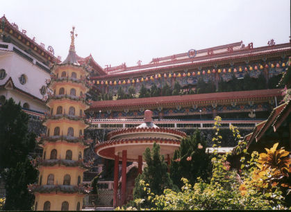
TourismPenang's historic architecture is centred mainly in George Town. Its rows of 100 year-old shophouses and colonial villas give Georgetown its distinctive atmosphere. Penang was the venue for several historical movies, such as Anna and the King and the French film Indochine. The best way to capture Penang�s mixed heritage is to stroll around town. The aged buildings are noted for their faded colours and crumbling walls. Old houses have columns or multi-coloured Peranakan tiles. The Aceh Mosque is the oldest house of worship in the city. The smell of incense drifts in the air amidst gold settings of Burmese, Thai and Chinese temples. The Khoo Kongsi is a traditional form of Chinese art with its delicately carved wooden panels. Other long-time occupants include elderly Chinese shopkeepers, colourful Indian food stalls and trishaws with their drivers. |
||||||||||||||
|
|
|
|
||||||||||||
| copyright - designed by WSEAS | ||||||||||||||